Thursday, December 29, 2011

Patagonia sin Pare!

The sending spree continues! December in Patagonia has seen unprecedented amounts of hot weather and beautiful windless days in the mountains, with windows coming every week it seems like barely enough time to refuel relax and catch your breath before turning around and marching back to new objectives.
After the Brenner Route on Guillamet, I vowed that postholing and bergshrunds were a thing of the past, and got stoked on rock climbing in the Torre Valley. The approach is pretty long to get up to the basecamp at Niponino or Polacos, but so worth it for the sheer amount of spectacular clean rock on the west side of the Fitzroy Massif.
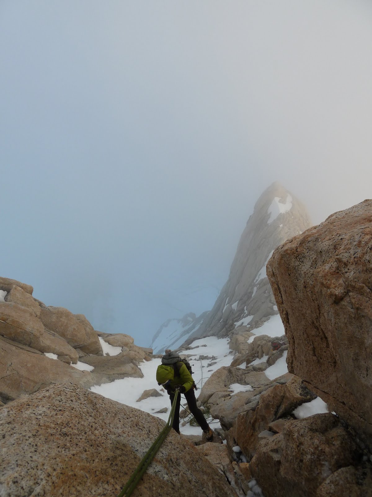
With legs about ready to fall off, got up to the bivy below Aguja St. Exupery, named after the famous author of the Little Prince and early Patagonian pilot Antoine St. Exupery, to climb the stellar uber-classic mega good never ending 5 star route Chiaro de Luna (800m 5.11b). This route just goes on forever, finger cracks, wild flakes, chimney of cracks... We got a bit hung up on some rappels and ended up not touching back down to the ground until 7am the next day, but what a killer route!

Ahgooha St. Exooperee

With a big asado to recharge the batteries back in town, I hiked back into the Torre Valley, solo this time, to climb a route on Aguja Rafael Juaraz, for another warm window scheduled for Christmas Day. But the miserable hike in with a death-load tired me out more than I expected, and I snoozed through my alarm! So leaving camp a bit later than planned, I changed the game plan to the Austrian Ridge on Aguja de la S, a more manageable and mellow outing.
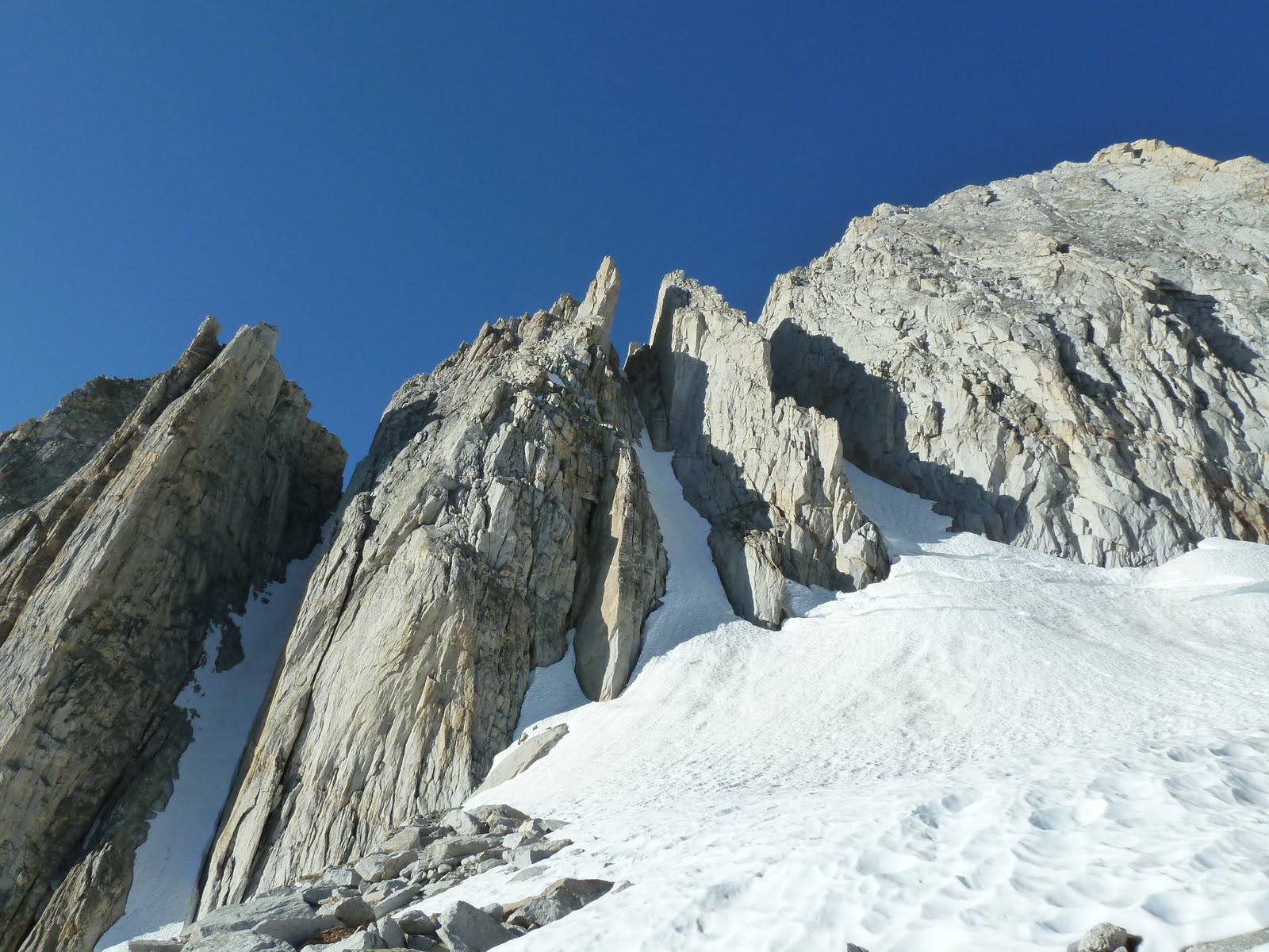
After a funky little rock step, I booted up about an hour towards the St. Exupery-de la S col, where I busted out the rope to make it up to a wild alpine bowl perched up below the summit tower. On the tower proper I followed a really cool chimney feature full of hand cracks and up to the wierd windswept fins right below the summit, climbing 5 roped pitches in all. What a rad way to spend Christmas afternoon, alone on a Patagonian summit, sun in the face, no worries.
I rapped back down with no hassles and made it back to my cave by 7pm for a nice dinner while watching the sun drop over Cerro Torre.


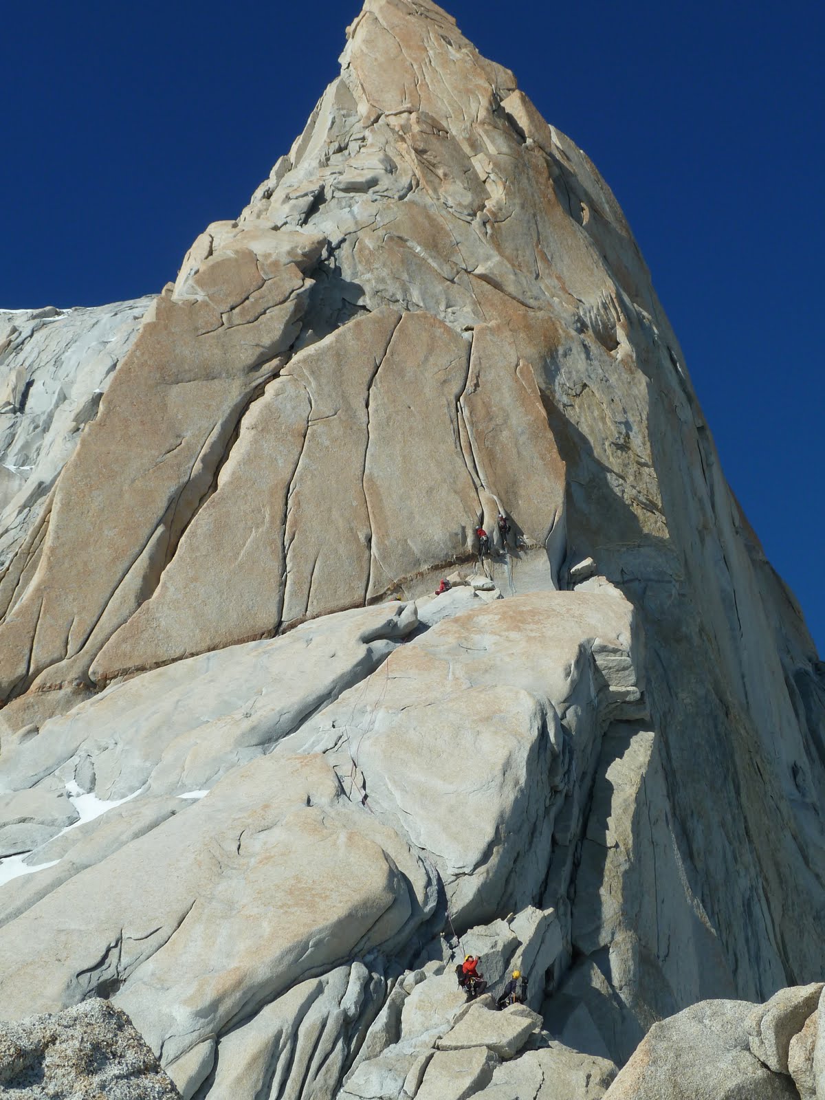
Awesomeness on de la S


Add ImageAdd ImageSummit tower


Now I hang out in Puerto Natales, Chile, to enjoy the New Year´s with friends here, and to renew my visa before heading back to Chalten for another month of getting after it, this time with my good friend Geoff who is making his first trip here. Stoked!!

Friday, December 9, 2011

Patagonicos Desperados


Greetings from the hot and cramped internet cabanas of El Chalten! For the last 3 weeks I have been getting after it as much as could be hoped for here in the land of the worst weather in the world. Despite being just off the couch from a chest injury that threatened to put my season on hold, I got into town, met up with my climbing partner, and headed straight for the hills.

The forecast looked chilly, so we racked up ice screws and tools instead of rock shoes and cams, heading for the Guillot couloir on Guillamet, a nice ice and mixed outing. Instead, we got super warm weather and waist deep snow. We did not send.
Next week we got a great 4 day window, and headed up towards Paso Superior to attempt the Franco Argentine Route on Fitz Roy. Intending to go all the way to la Brecha, we had to break trail through knee deep snow for hours, then climbing about 200 meters of steep snow and mixed climbing before arriving at the bivy at 11pm. After 17 hours approaching, we were obviously not set up for success, and I reached my fatigue point after only 6 pitches up the Franco.

We descended the next morning back to Paso and slept all day in the sun, recouperating for the Whillians route on Aguja Poincenot (600m 5.9 60deg). Leaving at 2am from Paso, we wallowed for hours up the glacier, managing to cross the bergshrund easily, and headed towards the snow ramp which defines the route. Simul-climbing and briefly pitching out the long steep snow ramp, we made it to the shoulder in the mid morning, but not until after passing two funky mixed pitches whose belays were conveniently located beneath a torrent of cold water. The day was getting warm. We left the ice kit at the shoulder and started I began leading pitch after 70m pitch of rock, trending up and left around the formation, picking the line that offered the best mixture of fun and speed. After several hours we arrived at the summit block, took our turns straddling the narrow perch, and began the first of 17 rappels to make it back down the route. Lucky for us the rappels were pretty uneventful by Patagonian standards, despite being at times completely engulfed in the super thick cloud cover sweeping over from the west. Finally we got back onto the snow below the ramp, and had to confront our next big obstacle: the ´schrund. The bergschrund had melted out considerably during the heat of the day, and our nice and easy step across was now a 8-9 foot wall. With an incredibly unstable snowpack we couldn´t build a deadman to rap off, so I figured the best idea, at 3am and thinking only of the sleeping bag and water that waited for me at Paso was...to jump. So off came my crampons, slack was given to me, and I went for it. Sounds crazier than it was, but enough to get my heart pumping! The descent after that was miserable-postholing for another couple of hours through hard crust over powder, the wind knocking you down ever few steps. Ugg.


Whillians Route on poincenot.

Rapping into the mist!

A few days of good solid rest down in Chalten was all we needed before gearing back up and going back up through Piedra Negra to climb the Brenner Ridge on Guillamet (350m 5.10+) during a one day window the day before last. There were a LOT of other parties on the route, and we managed to pass some of them, hang out with others, and generally have a nice little party train moving up the route. We summited in great weather, rapped back down the Guillot couloir and hitched back to town just in time to catch the empanada place before it closed.

Kind of a junk show. Moments later there were parties on all 4 crack systems...

Token summit alfajor pic.


Mermoz, Fotz Roy and the Torre Massiff

Now what? Lucky for me there is at least 5 days of crap weather on the horizon, so I can finally get a solid rest and do some laundry! ryan

Thursday, October 27, 2011

Thar She Blows! Volcano Season in South America


There have been highs and lows in the past 3 weeks of being back in my basecamp town of Bariloche in Northern Patagonia, but it feels great to be back visiting with old friends and planning another big season in the Southlands.


With close to no time to decompress after arriving, which I barely did because of a bunch of BS with Argentine Immigration, I began an 11 day Alpine Training for the Outward Bound Patagonia Program. We drove over to Chile to spend some time working on snow skills and glacier travel before making a successful summit climb of Volcan Villarica. Heading to the west was a good idea, because the ash and sand is still a major deal in Bariloche after the Volcan Peyehue eruption in June, and it is still causing lots of air quality issues.


Villarica is pretty active. We have to call in for a go ahead every time we climb it. The lava glows as you approach in the early morning!


Anyway, we sent Villarica, packed up our camp and resupplied in a small town near the border called Currarehue, and made our way to the flanks of Volcan Lanin, a much bigger hunk of a mountain, rising almost 10,000 vertical feet off the pampa on the Argentine side. We climbed it from a camp at the base of the northern (Chilean) aspect, leaving early from our tents at 3 am. The winds steadily increased as we gained the large bench which normally serves as a high camp, and which was in the middle of a mega lenticular cloud, and we hunkered down for some evaluation time. We kept on going, moving in rope teams to manage big fall potential, and wending through halfpipes of rime ice reminicent of the mushrooms you experience atop many Patagonian spires, eventually reaching the summit at 3,770 meters after 11 hours on the move.


Lanin. Pretty massive hill...


Our teams headed back down and we drifted into camp at around 8pm, fairly wasted after a 15,500 ft. quad and calf busting elevation day. The training was a success, giving a lot of awesome instructors some more tools to use in the mountains, and in typical fashion, we had a great (wild) post trip at the Roxy nightclub in Bari.


The only major bummer during the trip was taking a hard fall being knocked over by severe winds while traveling over rock, and fracturing a rib. So now I hang out in Bariloche, staying out of the dust, waiting for it to heal so I can get to the next task at hand, heading back to the big spires in the south and visiting some of the less traveled corners of the parks.


Want a great way to spend your upcoming holday vacation? Come trek the W or full Circuit in Torres del Paine National Park, one of the most iconic hikes in the world!


ps...not my photos. our pics to come later...

Friday, September 30, 2011

Sierra Ice Climbing- North Peak Couloir

It has been a little while since plugging in any updates or trip reports, mainly because I haven't had a free moment since around June! The fall guiding season on the Eastside was pretty heavy, with a lot of time spent going up and down the North Fork of Lone Pine Creek to access Mt. Whitney and Mt. Russell. But in late August, what seems like an eternity ago now, I had a precious few days of R&R which I spent bolt clipping in Mammoth, hot-tubbing in the Owens Valley, and convincing my friend Mateo to come over and sink some front-points into the North Couloir on North Peak.

North Peak has really easy access compared to everything else in the Sierra, which is good, because we met early, and I only had time to drink one cup of coffee. The approach is mellow, winding around Saddlebag Lake and then cuts a beeline through the 20 Lakes Basin. Kinda pretty.


Then you get to the couloir and you are stoked! Tools? Check. Crampons? Check. Bluebird sky and sun on your back? Double check. This ain't ice climbing in winter folks. No need for a thermos of cocoa or triple puffy parkas.


The climb itself is about 800 feet long and around 45-50 degrees, of which we pitched out the initial bergschrund zone and simul-climbed the remainder.


A little rock scramble puts you on the top, and voila! Killer views for as far as the eyes can see.
It's too bad that after climbing such a bitchin' little couloir you can't end it with a romp up one of the finest alpine ridge runs in the Sierra...


Mateo, posing down hard.

Wait! You can! Immediately after decending from North Peak, you have 2 options: Go down, and slog your way back to the car like some fool, or continue up along the ridge to climb the North Ridge on Mt. Conness (5.6). If you choose option 1, God help you.
The North Ridge is a mellow, cruiser outing on bullet granite, with a couple fun downclimbs thown in to spice things up a bit.
Moving quickly through this varied terrain on such a gorgeous day is THE reason I climb mountains.


We got back down to the car at Saddlebag in the afternoon, and Mateo had to jet so that he could go continue working on his Master's Thesis on why youth need to reconnect with nature for health and well-being. I think we discoved the answers.


A couple days later I was waking up at the Shepard Hot Springs outside of Mammoth and was lucky enough to take some shots of a hot air ballooninst taking off on an Eastside scenic flight. Pretty cool place to drink your morning coffee.


For now, over and out. Ryan.

Thursday, September 1, 2011

Sierra Art Cards For Sale!

At the beginning of the spring, after a long season of sitting around waiting for weather windows in Patagonia, I decided to go sport climbing. This was a bad choice. I got severe tendonitis in both elbows and had to give up on a lot of big summer climbing plans. But there was a flipside; the amount of free time I was allowed gave me a chance to get back into a passion which I have ignored for the sake of climbing over the past years.

Since early summer, I have completed around 25 or 30 postcard sized watercolor and pen landscapes, from Ahwahnee Meadow down to the talus below Black Kaweah. I have shared them with only a few people, wanting to build up a small collection that could be shown as a whole. A few days ago I chose 5 of my personal favorites and have begun making them into greeting cards.


As I begin preparation for yet another season getting blown off the towers at the end of the world, I hope to sell these sets of cards to help get me down there, as well as to share this stuff with a larger community.

Set of 5 4"x6" cards including envelopes will be sold for $15 shipped, and as I get more established, more of the other cards will be printed and made available. Paypal works great. To order contact ryanahuetter@gmail.com
Thanks for the support! Ryan

Wednesday, August 10, 2011

Sequoia-Kings Oddysey


Yosemite has the big granite walls of El Cap and Half Dome. The coast of Northern California hosts the towering redwood giants. The Eastside has easy access to some of the highest peaks in the lower 48. Sequioa-Kings Canyon National Park has all of these things, as well as the deepest canyon in the the country (Kings, at 9,000ft), the largest living organism in the world (Giant Sequoia), and everything in between. California is truely a land of superlatives, and an extended visit to SEKI will make that very apparent.


Mt. Silliman reflected in Ranger Lake.


With 7 college-aged students from Boston to San Diego, I set out on a 22 day oddysey which would place us at the foot of hidden Sequioa groves, atop breathtaking mountain passes, swimming and sunbathing next to crystal clear (and mostly frozen) alpine lakes, and on craggy summits which reward the mountaineer with seldom viewed panoramas.


Evening in Big Arroyo.


The storm arrives!

An emphasis was put on curriculum based in natural history, ecology and geology of the Sierra Nevada, but many of my lessons taught themselves as we traveled through the many bio-regions of the Western Slope of the Sierra. Our program was also grounded in a leadership development curriculum, and our students took on more and more responsibility as they grew more confident after living and traveling in the alpine environment for so many days.


Dylan Pritel builds another rock garden below Blackrock Pass

Finished rock garden framing the Black Kaweah

A big thanks to Leia Berg with whom I had the fortune of instructing this program with and whose hard work helped make this trip a success.

West Ridge of Mount Conness

With a dwindling number of days before having to work a 22 day backpacking course in the Southern Sierra, and a dark and ominous forecast of mega thunderclouds and deadly lightening bolts threatening to unleash certain doom, Jonathan Cooper and I decided that the best course of action would be to climb to one of the highest points in Northern Yosemite, Mount Conness. Coop is a young gun who I have had the pleasure of working with recently, and who was coming directly off of an all-you-cn-eat cruise in the Caribbean, where he was not exactly getting into mountain-shape...
The West Ridge is super dooper classic. You cannot help but have a smile on your face the entire time as you hand traverse the wild granite wave which sweeps over the massive Southwest Face of Conness.
We climbed it in a mellow day from the trailhead at Lembert Dome and decended down to Saddlebag Lake and hitchhiked back into the park to get my truck.
The day was capped off by Coop's mom coming to town and treating us to a feast of fish tacos at the Mobil Station in Lee Vining.


The Youth, Coop.


Kinda cool position...

Thursday, July 14, 2011

White Mountains Traverse


I have gotten pretty good at burning the candle at both ends, and this summer has been no exception. Hours after returning to the front-country from Blackcap Mountain, I packed up again and drove over to Bishop to head out on a traverse of the White Mountain Range, with the Sierra Mountain Center.

This is an incredible 5 day off-trail trip that goes from the ancient bristlecone forests (which date back over 4,600 years!), up the lush and tranquil Cottonwood Creek, over the 14,246ft. White Mountain, and continues on over miles of rolling alpine tundra though Chiatovich and Pellesier Flats towards Boundary Peak at the far end of the range.


Can you count the rings? This tree is thousands of years old.


The White Mountains are often overlooked despite their proximity to Bishop, perhaps due to the lack of exposed white granite which the Sierra Nevada is renown for, but the Whites have a wild and unique feel to them as you coast along wind swept high alpine meadows, pick up old pieces of obsidian and chert arrowheads, imagine the Indian hunting grounds of long ago and look across your shoulder at the entirety of the Sierra Range laid out beside you.


Looking up at the summit of White Mountain


Luke contemplates the Pellesier Flats. Or is wondering how long til dinner...

A pair of bighorn sheep make the traverse look easy.

After 4 days at altitude which slowed our pace, we made the decision to head down on the east side into Nevada and opt out of Bounday and Montgomery peaks to the north. Dropping close to 4,000ft of elevation in several hours was laborious, but it gave us the opportunity to really see the changes in ecosystems as we dropped down into the desert.

After another hot day in Bishop, I drove up to Mammoth Lakes to visit with my friend Mike, and we were able to climb the super classic North Arete on Crystal Crag. I head out to Mount Conness tomorrow for a quick last minute alpine fix before beginning another 22 day course for the Outward Bound School in Sequioa-Kings National Parks.

Hasta la vista Alpinistas!

Wednesday, July 6, 2011

Blackcap Mountain, Northwest Couloir


I am recently back from a 14 day mountaineering course run for the Outward Bound School. For those of you not familiar with this year's snowpack, it was massive. And remains massive. This is normally a pretty fun course that goes out of the Courtright Resevoir area on the western slopes of the Sierra Nevada, and receives a mid-point horse-packed resupply, but with 4 to 5 feet of snow on the ground even at our 7,500ft trailhead, we ended up having to do a 12 day unsupported carry, and depart from a lower and farther trailhead. Pretty burly for 10 students who had not done much if any backpacking before, 3 of whom had never walked on snow! It was a steep learning curve to say the least. The objective of the trip was to climb the Northwest Couloir (1,200ft. 45-50 degree snow) on Blackcap Mountain, which is waaaay out there. With a crew any less strong, this would have been a bit of an overly ambitious goal, but our students rallied, and put down some serious off-trail, suncupped snow, sun-battered miles to get up to the McGuire Lakes basecamp.


My instructors, Rafi and Coop, did a great job of moving the students quickly over technical snow and rock, putting up six full fixed pitches as they gunned for the summit. With a camp to camp time of just over 9 hours, our group was worked, but very satisfied.

A lightening fast glissade back through the West Bowl got us back to camp and we hiked out in record time to the 4th of July crazyness at the Wishon resevoir. Special thanks to Dan and Stefan for the unbelievable pistachio encrusted rainbow trout at Woodchuck Lake!